

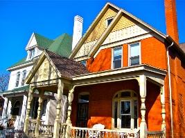
La Alma/Lincoln Park and Baker are among the City’s oldest neighborhoods. La Alma/Lincoln Park dates from the settlement of Auraria City, where the Auraria Higher Education Center is presently located. What is known today as La Alma/Lincoln Park neighborhood was annexed to Auraria City (the area of the Original Congressional Grant) under the Territorial Session Laws of 1874 and 1883. Ninety-three percent of the residential blocks were half or more developed before 1900, and the remaining 7 percent developed between 1900 and 1914. Although most of the original structures were lost to floods along Cherry Creek, the neighborhood’s character today is still shaped by the age of its homes. Many were built over 100 years ago.
Twenty structures within the neighborhood are listed in the Denver Inventory as having architectural or historical significance. Additionally, the neighborhood has a residential district on the National Register of Historic Places. That district, located on Kalamath, Lipan, and Mariposa streets between West 13th Avenue and Colfax Avenue, is an example of early Denver’s working class neighborhoods. La Alma/Lincoln Park also has one locally designated landmark, the Buckhorn Exchange Restaurant at 1000 Osage St. This Victorian commercial structure was built in 1885.
As Denver developed in the late 1880s, most construction projects focused on building homes and businesses. Prior to 1900, only a few sporadic attempts had been made to develop a park system for the growing city. A notable exception to this was the 15 acre site at West 11th Avenue and Mariposa Street which the city purchased in 1885 and named “Lincoln Park”.
Today, Lincoln Park serves as the focal point of the neighborhood. It is the site of the La Alma Recreation Center and numerous Mexican-American celebrations and festivities. “La Alma”, a Spanish word for “spirit” or “soul,” has been joined to the neighborhood’s traditional name, so that today it is commonly called “La Alma/Lincoln Park.”
As the “City Beautiful” movement caught hold in the 1920s, improvements came first to Speer Boulevard, the neighborhood’s eastern border. Mayor Robert Speer was credited with the idea of planting hundreds of trees along the boulevard that bears his name. During this era, the Denver school board also took a great interest in facility planning, and where possible located schools adjacent to parks. West High School, facing the sunken gardens of Cherry Creek and built in 1924, is a notable example of the aesthetically planned facilities which developed during this period.
The Baker neighborhood became part of Denver under the Territorial Session Laws of 1883. The neighborhood takes its name from John Hutchison Baker, a graduate of East High School and president of the University of Colorado from 1893-1915. By 1900, 82 percent of the neighborhood’s residential blocks were half or more developed. The remaining 18 percent of the neighborhood developed between 1900 and 1915.
The 1880s were a time of extensive real estate development in Baker. It was then that the Broadway Terrace subdivision in the northeast area of the neighborhood developed, including many homes designed by the noted Denver architect, William Lange.